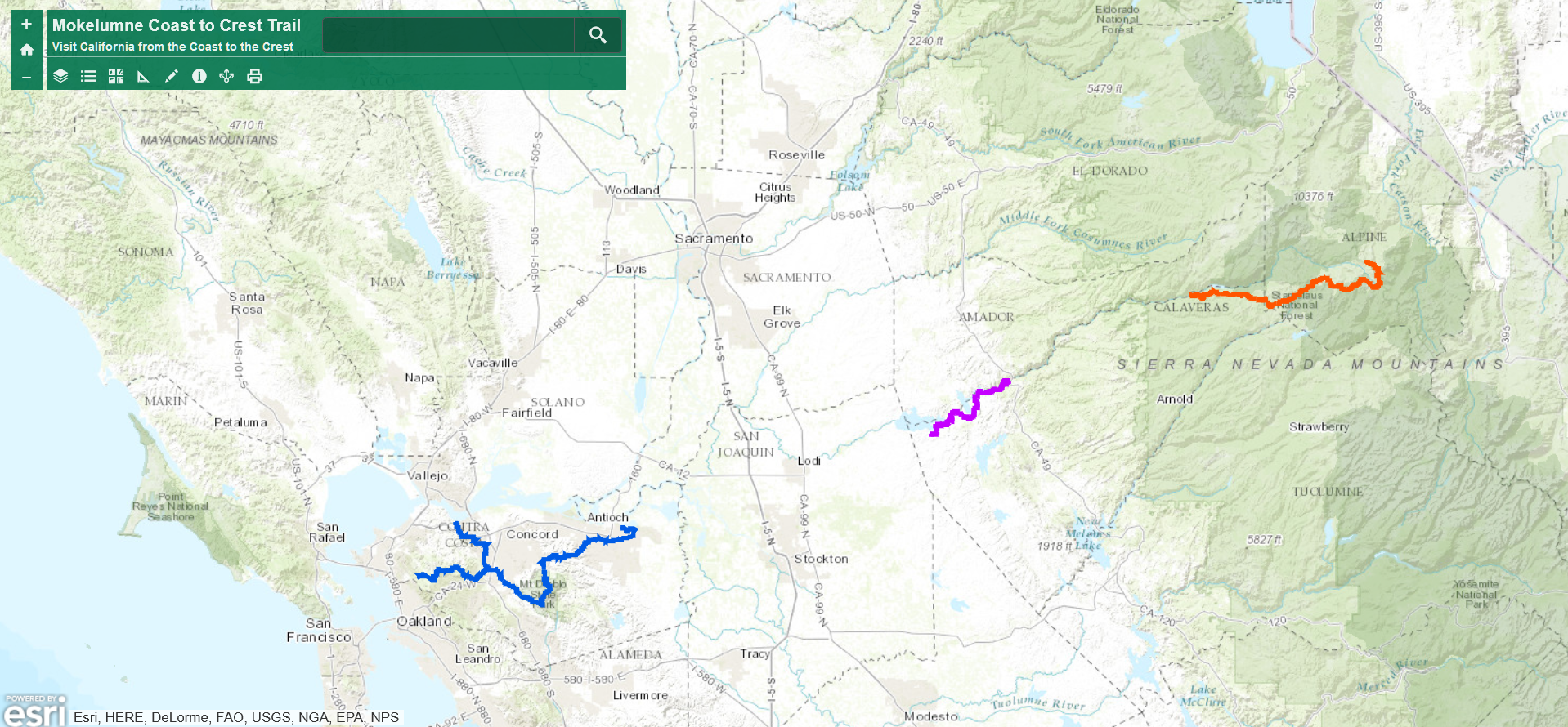
Waypoints (KMZ file) download page. Includes Rich Gulch. After downloading, view in a GPS app like Google Earth. This file is modified slightly from the original EBMUD KMZ file to highlight MCCT and day hikes.
Features
- For a moderate hike (5.2 miles round trip), head east from Rich Gulch to the Middle Bar Access point. You’ll follow the river canyon to the Middle Bar Bridge and pass through an area rich in history.
- Alternatively, head west from Middle Bar Access point which has developed parking and restroom facilities.
- If you wish, park a vehicle at one end and drive second vehicle to other end to start there for a 2.6 mile hike.
- For those wishing to hike further, a moderately challenging trail continues on Independence Loop (no livestock on this narrow trail)
- Peaceful
- Scenic views
Permitted uses
- horseback riding (access from Campo Seco trail head staging area located west of the trail)
- hiking
![]() Trail Information
Trail Information
Steep cross slopes with less severe trail grade changes. Physical barrier at Rich Gulch access gate may restrict unassisted wheelchair access
Rich Gulch Trail Description
- Permitted trail – purchase trail use permit online before your trip. Permit applies to you, your family, and 3 guests
- Altitude change = +55 feet, gently sloped
- Accessible outhouse at Rich Gulch Access point
- No dogs allowed on this portion of the EBMUD trail system
The trail traverses alongside the intermittent Rich Gulch Creek and the upper end of the Pardee Reservoir River Arm.
Camping
Camanche Recreation Area Campgrounds – North and South
Pardee Recreation Area Campgrounds
Turkey Hill Equestrian Campground
Note: Because of the intense boating & water activities at Camanche Reservoir from Memorial Day weekend through Labor Day weekend, Camanche campgrounds fill, but not Turkey Hill or Pardee Recreation Area Campgrounds.
Pardee Recreation Area is closed November through January.
Side Trips
- continue East, hiking the Independence Loop Trail
Parking at Rich Gulch Trail Access Point
- Please, no trailers – parking is primitive and narrow
- directions about 1.7 miles from Paloma Rd & 4.1 miles from Hwy 49 in Jackson
Rich Gulch Trail Safety
- Sign in at trailhead & carry your permit, use between sunrise and sunset
- Stay on trails, entering the water is prohibited for you and your horse
- Pack in your own water and snacks
- Carry a GPS and bring a friend along or share itinerary with a friend
- Signage – Where the trail is signed it is marked at intervals with oval green, beige and white logo signs on 4×4 trail posts
- Leave-No-Trace—The MCCT Council supports and encourages LNT practices while on the trail
- Camping – Not allowed on the trail
- Fire – Fire danger can be extreme, and fires, camp stoves, and smoking are prohibited
Rich Gulch trail was designed, built, and signed by EBMUD and EBMUD Trailbusters.

One thought on “Rich Gulch Trail”