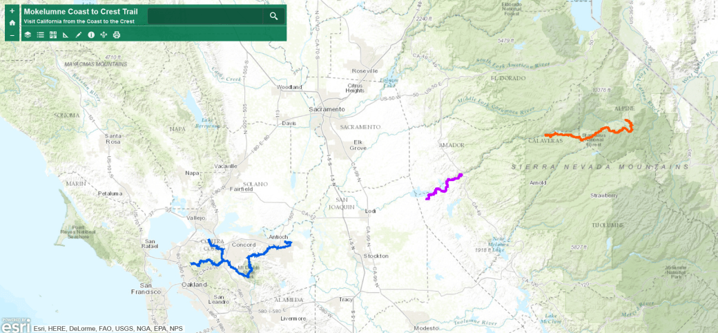
After opening map, type “Bear Trap Basin” in search field


Waypoints (KMZ file) download page. Includes High Country Meadows Trail. After downloading, view in a GPS app like Google Earth.
Features
- Day hike or jump off point into Mokelumne Wilderness
- meandering trail passes through two meadow valleys
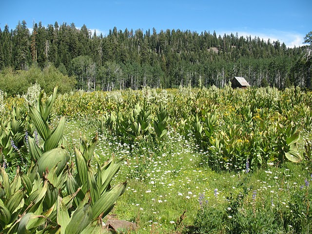
- Scenic views
- Mid season wildflowers (date varies), aspens turning in fall (date varies)
- Two ways to access
- Corral Hollow trailhead – challenging 357′ hike to ridge top
- Bear Trap Basin trailhead – access road is long, bumpy and dusty
- Staging for extended trips. Backpack or camp in Stanislaus National Forest or Mokelumne Wilderness
- Photo Album with trail, trailheads, staging areas & camping areas
Trail Places and Photos

High Country Meadows Trail Description
- Trail length one way – 4.6 miles
- Dirt surface, width varies, snow depth significant in the winter
- Shaded and unshaded
- Little to no cell phone service
- Post messages at Bear Trap Basin trailhead kiosk
- View in Everytrail on your device or computer
![]() Trail Accessibility
Trail Accessibility
Portions of this trail are wheelchair accessible
Side Trips
- Mokelumne Wilderness is northeast of the trail and east of Salt Springs Reservoir. Permit required to extend your visit beyond one day and is available at Hathaway Pines Ranger Station 35 miles south of Bear Valley on Hwy 4.
- The town of Bear Valley features restaurants, grocery, developed recreation excursions, & hotel
- Bouldering near Bear Valley
- Swimming, paddling, and boating at Union & Utica Reservoirs and Spicer Meadow Reservoirs just south of Tamarack, across the highway and down Spicer Meadow Rd.
Parking and Staging
Parking and roads are impacted by weather. Area trailheads inaccessible in winter and possibly into late spring by vehicle. Talk with the Calaveras Ranger District representative at 209-795-1381 when planning your trip.
- Corral Hollow Trailhead
- primitive parking area, trailers not recommended – no turn arounds
- directions From hwy 4/49 in Angels Camp to trailhead
- Bear Trap Basin Trailhead
- directions from hwy 4/Forest Service Road 7N09
- drive on 7N09, right on 7N11 to 7N11A to trailhead (7.5 miles total)
- entry road is unpaved, check with US Forest Service Calaveras Ranger Station at 795-1381 before accessing
- directions from hwy 4/Forest Service Road 7N09
- Nearby staging areas for trailers
- staging and dispersed camping at the MCCT Bear Valley trailhead across the highway from Bear Valley
- staging and dispersed camping off Spicer Meadow Road, near Spicer Meadow Reservoir
High Country Meadows Trail Safety
- Stay on trails
- Pack in your own water and food
- Carry a GPS and bring a friend along
- Weather changes rapidly in the high country. Check the weather before going on the trail or be prepared for adverse weather
- Signage – where the trail is signed it is marked at intervals with oval green, beige and white logo signs on 4×4 trail posts
- Leave-No-Trace—The MCCT Council supports and encourages LNT practices while on the trail
- Fire – Fire danger can be extreme, see Stanislaus National Forest‘s rules and regulations
The High Country Meadows trail was designed, built, and signed between 2000-2010 by the US Forest Service and the Mokelumne Coast to Crest Trail Council.
