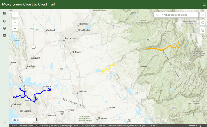
Click image and zoom in on purple trail
- Blue – East Bay – Contra Costa County
- Yellow – Camanche – Pardee
- Orange – Upper Mokelumne River Canyon
- Delta and Middle Mokelumne Segments are not reflected here, their alignment is not defined
Waypoints generated by EBMUD (KML file). After downloading, view in a trail map app like Google Earth.
Waypoints for MCCT day hikes only (not available in EBMUD generated file)
Description
Western boundary at the southwestern end of Camanche Reservoir. Eastern boundary at Hwy 49 crossing of the Mokelumne River. EBMUD lands contain 32 continuous miles of hiking and horseback riding trails.
Hikes
Easy James Bar Trail
Challenging Independence Loop Trail John Bull Trail
Activities
Hiking, horseback riding & camping activities require a permit on EBMUD lands. Click here for more information.
Biking is not a permitted activity on this portion of the East Bay Municipal Water District trail system. Dogs permitted along trail west of the Camanche South Shore Staging Area,
![]() Trail Accessible
Trail Accessible
EBMUD’s accessible trail inventory.
Points of Interest
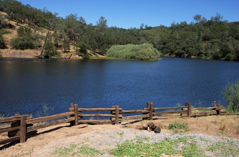
- Middle Bar Bridge is a beautiful reminder of early 1900s architecture
- Cultural Sites abound in the area reminding us of the rich history of times past
- Gwin Mine was a highly productive gold mine in the mid 1800’s
- Wildflower walks in early Spring, courtesy of Joel Metzger
- Cooks Mesa Trail Access Point: To make day trips easier between Camanche South Shore Staging Area and the Campo Seco Staging Area, the 12.4 mile distance is now broken up by the new Cooks Mesa Trail Access Point. The new trail access is 3 miles from the Camanche South Shore Staging Area, 10 miles from the Campo Seco Staging Area, and 100 yards south of the Mokelumne Watershed Headquarters on Camanche Parkway S. Cooks Mesa has potable drinking water, handicap-accessible chemical toilets and limited parking. Trailers are prohibited due to the small parking area.
- Patti’s Point: A popular section of trail, traveling east from Patti’s Point to James Bar trail is a short but steep segment of the MCCT offering dazzling view of the Mokelumne River. The point is also accessed by descending east for roughly one mile west of James Bar Trail. Access at Rich Gulch Staging Area/parking.
Day Hikes
- James Bar Trail
- Rich Gulch Trail: For a moderate hike (4.2 miles round trip), head east from Rich Gulch to the Middle Bar Access Point. You’ll follow the river canyon to the Middle Bar Bridge, and pass through an area rich in history.
- Independence Loop: EBMUD opened this last section of Mokelumne Coast to Crest Trail on District land in October 2012, completing the segment. Enter and exit at the Middle Bar Trail Access Point. The 3.7 mile trail offers a loop aspect for pedestrians, following the narrow gauge along the river canyon (stock are excluded from the canyon section for safety reasons).
Access
- Download waypoints. After downloading, view in a GPS app like Google Earth. This file is modified slightly from the original EBMUD KMZ file to highlight MCCT and day hikes.
- See maps below and trail guide. EBMUD protects these watershed lands to ensure a safe water supply. For this reason, all trail users & campers must follow the use rules and individuals using any hiking and equestrian trail on EBMUD property must have in their possession a valid EBMUD trail permit and sign in at trailhead kiosks.

 Click the map to visit EBMUD’s online trail map
 click image for full size view of Turkey Hill Campground
Turkey Hill campground is located on 16 acres adjacent to the trail at Campo Seco Staging area in the South Camanche area. Sites are available by reservation to equestrians first and youth groups when not reserved by equestrians. Contact the Camanche Recreation Company at (209) 763-5178, weekdays from 10:00 a.m. until 5:00 p.m.
click image for John Bull Loop Trail PDF
Current Segment Status
Trailer parking is prohibited at Middle Bar Take Out parking lot and Rich Gulch Trail Access Point due to limitations in parking and access. Read more about trail status on the EBMUD trail website. See closures due to extreme weather in 2017 at the top of this page, in red.
Remaining Work to Complete Segment
The Segment is complete!
- Rich Gulch Trail: For a moderate hike (4.2 miles round trip), head east from Rich Gulch to the Middle Bar Access Point. You’ll follow the river canyon to the Middle Bar Bridge and pass through an area rich in history.
- Middle Bar through Independence Flat: In October 2012, EBMUD opened this last section of Mokelumne Coast to Crest Trail on District land. Since the trail alignment east of Highway 49 isn’t established yet, trail users enter and exit at the Middle Bar Trail Access Point. The trail offers a loop aspect for pedestrians, following the narrow gauge along the river canyon. Livestock are excluded from this canyon section for safety reasons. (MCCT calls this section the “Independence Loop Trail”)
Accomplishments to date by EBMUD
- built John Bull Loop Trail, (about seven miles) opened in June 2016
- started MVP (Mokelumne Volunteer Partners) provides many ways citizens can participate through Volunteer workdays — Docent support – Research
- developed & managed the Mokelumne Trailbuster volunteer program since 1992
- built 29.2 miles of trail
- built 3 staging areas
- installed 3 bridges
- built the Turkey Hill Equestrian/Group Campground
- published a trail guide
- published ADA access designations
- published a paper and online trail map, available with the purchase of your annual trail permit
- a wildflower checklist within the Camanche & Pardee Watersheds
- “The Longest Mile” story – sharing the construction of “the Longest Mile”. EBMUD Trailbusters and California Conservation Corps members who built it call it “The Longest Mile” because it was carved and built into the steep canyon wall over a period of 10 years, in part on steps and in part on trail-bed of carefully stacked rocks.
Partners
East Bay Municipal Utility District email: recreate@ebmud.com
Contact: 209-772-8204
Mokelumne Volunteer Partners
Contact: Justin Mynk, Senior Ranger Naturalist, 209-772-8259
Upcoming Events and Volunteer Opportunities – view MCCT calendar (no opportunities planned at this time, contact Justin Mynk for EBMUD volunteer opportunities)
Past Events
Longest Mile Trail Wildflower Walk
Mokelumne River 50 Mile Run/50K/Marathon/8 Mile Trail Runs
Sierra Lodestar’s reporter, Dean Fleming, writes about how much he thinks the nearby China Gulch trail ROCKS!
More Information
MCCT Segment Coordinator
Contact: Steve Diers, Segment Coordinator, sdiers1991@gmail.com, (650) 560-8836
