blog posts page

5th Annual 50M/50K/13.1M held today, April 18th!

Single Track Running sponsored the annual Mokelumne River 50M/50K/13.1M awesome trail races along the Mokelumne Coast to Crest Trail. Learn more at Single Track’s website.

map Mokelumne-River_250px

The race course is again along the beautiful Mokelumne Coast to Crest Trail. View pictures and details at the Single Track Running’s website.

4th Annual 50M/50K/Marathon/Half Marathon/8M is April 19th!

Join Elemental Running for the fourth annual Mokelumne River 50M/50K/Marathon/Half Marathon/8M on April 19th. Finishers of the 50m and 50k will receive a finisher’s jacket from Fleet Feet Stockton!

Mokelumne-River_250px

The race course is again along the beautiful Mokelumne Coast to Crest Trail. View pictures and details at the Elemental website.


3rd Annual Mokelumne River Run announced

Join Elemental Running for the third annual Mokelumne River 50M/50K/Marathon/Half Marathon/8M. New this year — Half Marathon and support from Fleet Feet Stockton!

Race course is again along the beautiful Mokelumne Coast to Crest Trail. Visit Elemental’s website for pictures and details.

April 20th, 2013
6:00am
(Half Marathon and 8M start at 7am)
Camanche Lake South Shore Staging Area
 

Independence Flat Loop Trail Highlights

This map shows MCCT’s last area under construction by EBMUD. June 2nd, National Trails Days, is set to be an historic day! EBMUD estimates this trail’s construction will finally be completed.

Notable facts:

    • Over 1.16 miles of abandoned water ditch between Middle Bar and Big Bar will be developed as part of the new Independence Flat loop trail
    • This loop does not extend or connect east to BLM’s new Mokelumne River Whitewater Trail Big Bar Launch & parking lot at Hwy 49
    • New river access will be available along the trail. EBMUD will provide this information after the loop trail is opened. View the Google map below to learn more about river access using EBMUD’s Middle Bar Take Out located just across the river

Progress to Date:

    • Conversion of ditch remains to trail tread started in August of 2011, relying on hand tools and hard work. On average, the crew completes 150 feet a day.
    • The cross-country portion of trail is being built on 60% to 75% cross slope using a 1-ton mini excavator. With around 1,050 feet of the cross country portion complete, that leaves a balance of about 400 feet. Several gulch crossings were also developed.

Saturday June 2, 2012 – National Trails Day on EBMUD’s MCCT Trail


 Assist EBMUD Rangers in building a portion of the proposed 300 mile Mokelumne Coast to Crest Trail near Mokelumne Hill, California. From our start location we will hike in about 1 mile with our tools and gear to the job site.Participants should be prepared for warm to hot weather and bring a bag lunch, hiking shoes/boots (no open top shoes), backpack, ½ gallon of water minimum, sunscreen, insect repellent, long pants (to protect against stickers. poison oak & ticks), binoculars, and camera for the event.

This is a strenuous but rewarding work suitable for those 14 and older. Advanced registration required. RSVP with Ranger/Naturalist II Steve Diers

Mokelumne Ultra Marathon is back


Another awesome trail race through the wildflowers! Sponsored by

April 21st, 2012
6:00am
(8M starts at 8am)
Camanche Lake, California
Camanche Lake South Shore Staging Area

Register Now!

This event is limited to 100 runners, so register early!

COURSE

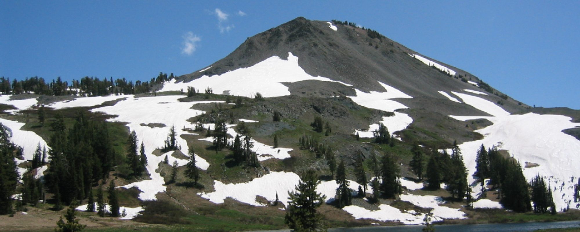
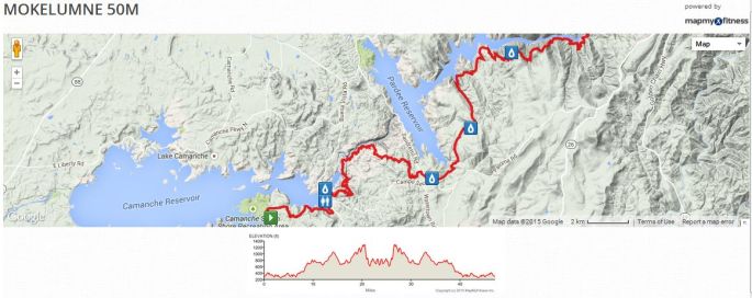
The out-and-back course runs along the Mokelumne River Coast to Crest Trail and winds along the Mokelumne River past California’s historic mining towns and old mines.  Drink in the beautiful scenic views of Camanche and Pardee Lakes, oak woodlands, gorgeous wildflowers, the “Longest Mile Trail,” and wildlife that often includes the majestic Bald Eagle.

Course Map

WEATHER

April sees typical temperatures in the 50s ⁰F and 60s ⁰F, with high humidity.

AID STATIONS

Aid stations will be located every 4-8 miles and will stock a variety of hydration and nutrition.

Aid station Miles Next Aid Crew Drop Bags
Start 0 4.1 X X
Lancha Plana Bridge
(8M Turnaround)
4.1 8.3
Campo Seco Staging Area
(Marathon Turnaround)
12.4 4.1 X X
McAfee Gulch
(50K Turnaround)
16.5 6.9
Gwen Mine Rd Crossing 23.4 2.3 X
Middle Bar Takeout
(50 Mile Turnaround)
25.7 2.3 X
Gwen Mine Rd Crossing 28 6.9 X
McAfee Gulch 34.9 4.1
Campo Seco Staging Area 39 8.3 X X
Lancha Plana Bridge 47.3 4.1
Finish 51.4 0 X X

PERFORMANCE RULES

  • Runners must wear their official race number on the front of their person, where it must be visible at all times.
  • Each runner must complete the entire selected course under their own power in order to be eligible for a finisher award.  Changes to a different distance are allowed provided they are communicated to an aid station as well as upon completion of the race.
  • Each runner must carry all their own food, fluids and other supplies needed for use between aid stations.
  • Runners may not accept aid from a support crew or any other source while on the course and in between aid stations and designated support locations, except in case of a medical emergency.
  • Any entrant who is unable or does not desire to finish the race must continue to the nearest aid station. The runner must relinquish their race number to the aid station captain and state their decision to withdraw.
  • Absolutely no littering.  Please respect the natural beauty of our trails and the rights of everyone to enjoy them.

RACE START & TIME LIMITS

  • 50M, 50K, and Marathon distances will start at 6:00am
  • 8M will start at 8:00am

13-hour time limit for all distances.  The course will close promptly at 7pm.

All times are local time (Pacific Daylight Time) on Saturday, April 21st, 2012

FEES

Online registration closes at midnight, Thursday, 4/19

50M  $70
50K    $50
Marathon    $50
8M     $35

If the race does not sell out, we will accept registrations at Packet Pickup Race Morning.  Entry fees increase $10 at Packet Pickup.

**You must register by Thursday, April 12th in order to be guaranteed a shirt and your requested size!

Register Now!

CAN I GET A VOLUNTEER?!

Volunteers are an essential element of any race, but especially for trail races.  And we have some of the best!  Interested in volunteering?  Let us know here.  In additional to a sweet volunteer tee (you know you want one!), we thank you with free entry into any ERT race this year.  And lots of hugs and kisses.

PACKET PICK-UP

Race Morning
Start/Finish Area
5:00-5:45am  (All distances)
7:00-7:45am  (8M)

RACE DAY

All participants will receive a technical shirt, a finisher award (upon completion of the registered event), and goodie bag.  Awards will be presented for the top men’s and women’s finishers in each race.

Each participant will receive a raffle ticket for entry to win one of the raffle prizes provided by Elemental Running and Training and its generous sponsors and partners.   Additional tickets will be available for purchase for $2 each or three for $5.

Winners must be present to receive all finisher awards and raffle prizes.  No awards or prizes will be mailed.

FINISH FESTIVAL

All spectators, crew, friends, and family are welcome to relax at the start/finish area and enjoy the atmosphere while cheering on their runners.  Plenty of food and beverages will be available, as well as a post-race barbeque.  Additional meal tickets are available for purchase for $7.

Donations will be accepted on behalf of the designated charitable beneficiary.

The festival area may include booths and displays by ERT partners, with product samples, demonstrations, and items for sale, so don’t forget to bring some cash.

Sponsorship opportunities are still available, so contact ERT today if you or your organization wishes to be represented at the festival.

TRAINING PROGRAMS

Train with Coach Jimmy and be ready for race day! Learn about coaching opportunities with Coach Jimmy.

RESULTS

Coming April 23rd!

6 spots available!

June 9-10, 2012.  Time:  10:00 AM Saturday to 5:00 PM Sunday.
Leave No Trace Trainer Class
Salt Springs Reservoir (Mokelumne Wilderness)
Backpack Outing 2-day
Learn through experience how to share the 7 Principles of Leave No Trace during this two day training taught by Tom Banks, Master Trainer of Leave No Trace and longtime wilderness ranger for the U.S. Forest Service and National Park Service. We will teach each other backcountry Leave No Trace hiking and camping skills during an easy overnight backpacking trip; our location is tentatively set at Salt Springs Reservoir within the Mokelumne Wilderness which is about 35 miles from Pioneer, CA. Our first day we will hike about 2.5 miles to our campsite, “500 Dollar Camp” which will be our classroom for the 2 days. Our hike out will be the same way on the 2nd day.  Participants will need to provide their own food and camping equipment and have a basic knowledge of how to backpack. Cost for the training will be $50 per participant. More information will be sent by email in early May. There are only 6 spots available for this training so register early! Contact: Mari Praus at 209-242-4845 or grloutdoor@gmail.com to register and for information.

West Calaveras Rotary: Handshake

The Trail Council provided a trail update yesterday at the invitation of the esteemed West Calaveras Rotary meeting at La Contenta Golf Club in Valley Springs. We highlighted what’s happening in their backyard along the Camanche-Pardee Reservoir shores. Here’s the short presentation:

Along the James Bar Trail near Valley Springs

Caution: It’s still a bit treacherous out there for high country hikers

Spring Safety Tips. Yes, spring safety tips.

It is not a typical July in California’s Sierra Nevada. The snow pack is so dense that it’s like early May out there, but with July temperatures.

There’s a lot of snow out there. There’s so much snow that it’s still blocking access to some mid to high-elevation trailheads. And in the recent heat we’ve had, it’s melting fast. The snow will melt more readily on a south-facing slope, but then you turn around a little corner and the trail is gone. … And when you get to the snow, it gets deep really quickly,

The hazards are many. They’re out there every spring, but the hikers aren’t, at least not in great numbers. But with July and summer temps upon us, people want to get out and explore. This year, they’re finding downed trees, snow obscuring trails, slippery snowfields to cross, and very, very swollen rivers and creeks. Some streams are running so high that they cannot be crossed safely, and hikers need to be ready to turn around and call it a day if they encounter such conditions. Streamflows can increase as the day heats up, too.

Throughout the mountains, a particular danger is posed by “snow bridges,” where snow that typically might have melted by now covers a stream running underneath, making it “invisible” and capable of easily dropping you 10 to 15 feet into an icy torrent.

Hikers are advised to have good “route-finding skills” and to check updated trail conditions before starting out. They also should carry maps, compass and/or good GPS equipment, and know how to use it. Cellphones can be invaluable in an emergency, but hikers should not expect cellphone coverage in remote mountain areas.

As of July 4th Stanislaus National Forest Ranger Station in Hathaway Pines is not reporting closed trails, opting instead to put out appropriate advisories about the abundant snow on trails in the high country and relying on hikers themselves to take necessary precautions and preparations.

Cell phone service is spotty in the mountains, and that it can take several hours for Search and Rescue to arrive if called. You have got to be prepared to deal with an accident or injury without help for a lot longer than you think.

This is where we plead with you to remain alert. Please, please read our safety tips, even if you are an experienced hiker. Refresh your memory. Forward them to your hiker friends. Always carry the Ten Essentials. Brush up on your wilderness first aid skills.

Be over-prepared this year. Hike extra smart this year.

Decades of trailmaking honored

Ranger Naturalist Steve Diers was honored last month at the California Trails and Greenways Conference with a Lifetime Professional Achievement Award.

June 6, 2011
East Bay Municipal Utility District LOG
Vol. 41, No. 11
By: Abby Figueroa, EBMUD Public Information Representative

In 1990, Steve began his career at the District with the Camanche ranger unit. Previously he worked with the East Bay Regional Park District (EBRPD) for 14 years where he led equestrian tours and managed trail crews and volunteers.

Two years after starting at the District, Steve launched EBMUD’s award-winning Mokelumne Trailbuster volunteer program in the Pardee and Camanche watersheds. He has worked with volunteers every other Saturday to build a 32-mile segment of the Mokelumne Coast-to-Crest Trail along EBMUD property. He and the Trailbusters have completed 28 miles so far.

“My best memories on the job are working with the volunteers and operating the trail dozer to build the trails,” Steve says. “Putting my energy into this work then watching people use and enjoy the trail – knowing they are seeing wildlife and having a unique experience with the vistas, the Ranger wildflowers, the wildlife – that’s how I know I’ve done my job.”

Photo text: Naturalist Steve Diers leads a group hike.

More than 24 years in the making, the Coast-to-Crest Trail is envisioned as 300 miles of continuous trail that begins on the shores of San Francisco Bay and heads east to Ebbetts Pass in the Sierra. At various points it crosses EBMUD and EBPRD lands. Some sections of the trail are so rugged and remote, California Conservation Corps members had to camp nearby and hike in with Steve every day hauling tools and supplies.

“My goal is to finish the easternmost segment between Middle Bar and Highway 49 before retiring next year,” he says.

“Steve and I started on the same crew 21 years ago,” says Ranger Supervisor Chris Swann. “He has worked tirelessly to make the Mokelumne Coast-to-Crest Trail vision a reality. Through his efforts, progress continues and the public sees another shining example of the District’s commitment to community and the environment.”

Throughout his career Steve says he’s seen 13 mountain lions while on the job.

“This job is like working in a bakery or a candy store. Everywhere there are natural, cultural and historic features you just can’t get enough of! There’s the canal cave with the Native American pictographs; the Wildermuth home, a historic stone house built in 1861; and a portion of the trail between James Bar and Patty’s Point that is famous for the wildflowers,” he says.

Steve says to be a successful ranger you need to have stamina, be a jack-of-all-trades, be self-motivated and be able to work alone in remote locations.

“You have to be committed, interested in nature and want to share the information you have about the outdoors with the public,” he says.

“I do enjoy my job, but I also believe it’s important if you are spending 40 hours a week on a job, you feel you are making a difference.

Photo text: Steve says to be a successful ranger you need stamina and commitment. He is the tenth recipient of the California Trails and Greenways Conference’s Lifetime Achievement Award.

For me that has been working on the Coast-to-Crest Trail, conducting the tours, reaching out to the communities where we live and work, and recruiting volunteers” he says.

He adds, “I work with great people with myriad skills and abilities. There’s a great sense of collaboration and humor in this division.” He says that everyone in the division gets involved in the trails and volunteer program in some capacity.

“There are a lot of people I’d like to thank as I receive this award including my co-workers, the Mokelumne Coast-to-Crest Council and the Trailbuster volunteers. The volunteers, many of whom are retirees and from outside the area, have an impressive commitment and I am humbled by what they do.”

Steve and his wife Stephanie live in Glencoe, a town located 22 miles from Pardee Dam.

— reprinted with permission from East Bay Municipal Utility District